Friday, August 3, 2012

Chilkoot Trail Run July 2012

Last Sunday I ran the Chilkoot Trail again with two friends, Mary and Amy. The weather was starkly different than the hot sunshine of July 2010, but better in many ways for a 35.5 mile grueling trail run. It was high overcast until after Bare Loon Lake (mile 29) when the sun popped out for our 5.5 mile jaunt on the tracks.

Here we at 5:00 a.m. fresh, energetic, permitted, and ready to go!  I was carrying three home-made energy bars (pecans, walnuts, almonds, jasmine rice, Cinnamon and crushed Special K - how's that for avoiding added-sugars?), two sandwiches with peanut butter and plain strawberries, one small container of Gatorade and one package of energy blocks (so much for avoiding added-sugar). I was also in charge of the Iodine tablets.


We ran at an easy pace through Finnegan's camp, stopping to say good morning to a 7 year old camper and then on to the Canyon City ruins (7.8 miles) and Pleasant Camp (10.5 miles).


Here's Mary crossing the suspension bridge. 
 I should've taken a photo of the gorgeous, rushing water beneath.  But, fortunately, there was plenty of water ahead on the trail.  We stopped at Sheep Camp (mile 13) to fill our hydration bladders.  Then the trail quickly became steeper and rockier.  We had completed 1/3 of the run.  The Chilkoot is the length of 3 half marathons.  The middle half can be grueling with the rocky uphill, snowy descent and often nasty weather at the pass.  The first and third half marathon sections are easily runnable if you're in shape and like trail running.


And, as we headed up to the pass, we were quickly exiting the Southeast Rain forest and entering the rocky alpine.  The climb from Sheep Camp to the Chilkoot Pass is only 3.5 miles but it's the hardest part of the trail. 


Here, I was relieved to be trail-running with five pounds on my back rather than hiking with a 35 pound pack. We were a bit apologetic about our light loads as we passed several beleaguered hikers.  


Here's a photo of Amy keeping a steady pace through the rocks.  We started to see snow patches over the rushing stream up ahead.


The National Parks Service website indicated that the trail was snow-free south of the pass but we definitely found some snow. Here's the link to the park services website:  http://www.nps.gov/klgo/planyourvisit/trailconditions.htm


Here are Mary and Amy close to the scales beneath the Golden Stairs (actually Grey Rocks).  It's hard to believe that the prospectors carried thousands of pounds up to the pass, including a piano for the bar hall in Dawson City.  Our priorities were simpler; we stopped and munched on power bars and re-tied our shoelaces for the big climb.


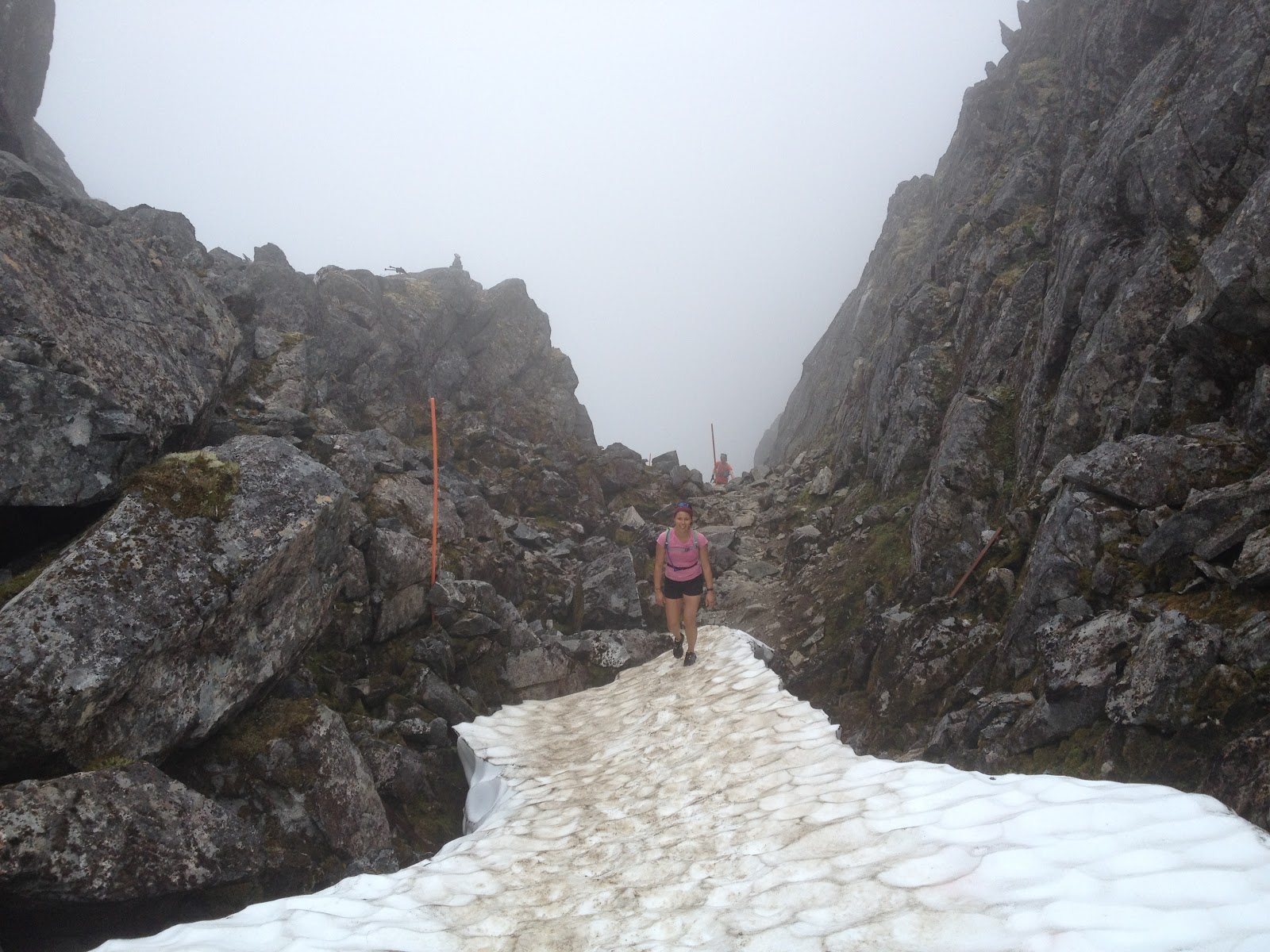
As you can see, the pass was all socked in.  I was so pleased with the cool, ideal running conditions, that I didn't mind foregoing our gorgeous view at the summit (well, almost didn't mind).


Amy is the skinny, orange dot in the middle, right side of the above-photo not to be confused with the skinny, orange fog marker in the photo's center.


Here's Mary nearing the first plateau.  Is she running up the huge, jumbled, slabs of granite?  Someone needs to talk to her.
Chilkoot Trail Profile
Above is the elevation chart for the Chilkoot Trail.  Guess where the picture below was taken in terms of elevation?  Right - close to the peak.

We're getting close to the Canadian Ranger's Station at the pass (and the international border) and our lunch break.  Amy is signaling that she doesn't have her passport and thereby saved herself 9/10s of an ounce in pack weight.

Now we were steps away from British Columbia and so excited that the cute Canadian Ranger let us into his warm cabin that we forgot to take photos of it or him.  Also at this time a female hiker lugging a large pack was barraging Mary with questions about our running history and whether we would run the trail again with her next summer.  Unfortunately (or possibly fortunately), we didn't get her contact info.


Here comes Mary down the pass, hoping not to slide into Crater Lake.


Crater Lake is stunning.  We were running through a fair amount of snow at this stage and at a healthy cant.  Amy displayed rare athletic, gymnastic movements along the hill here and saved herself from a nasty glissade into the water, making me think I need to start yoga or something.


In 2006 I swam in Crater Lake in the warm sunshine.  Hhhhmmmm...not this year.


Did you know that British Columbia's motto is "splendor without diminishment"?
Fitting.


And snowy.  Once we were down the first hill it wasn't too bad and may have been faster than running the rocky trail.
Here's Mary about 18 miles into the run.  We thought the snow was over...


Wow, were we wrong!  This is a lot of snow on the Chilkoot Trail in late July.  It was gorgeous but a bit technical at times.

Such a large amount of snow probably won't all melt before the September snow starts anew.

Here Amy demonstrates her cool in jumping from the snow to the rocks.  You probably wouldn't want to fall right there unless you enjoy being wedged between rock and ice.

A snow tunnel just for us!  Oh yeah...and the 30 other hikers on the trail.

Here's Mary demonstrating how to correctly navigate a stream crossing by jumping from rock to rock.  Maybe this is why three hours after the run my feet were squishy and palid sans one toe-nail and Mary's looked like other people's feet.

Hey, an actual trail.  What a concept.  No more snow.

Here's Mary at Happy Camp.  Doesn't she look happy?  Only 15 miles to go.

So after part of a sandwich, we were off again.

This photo was taken shortly after Deep Lake (mile 23) where the water funnels into a waterfall and drops beneath us.  We started watching for bear signs because according to the Parks Service there is a big bear patrolling back and forth between Deep Lake and Lindeman City (mile 26).


There is a gorgeous downhill section shortly after this photo location where we cruised into Lindeman City. I love this part of the trail, it's fast, downhill and smells like pine. It's funny because I always remember this section as being far longer than it is. Does that make me an optimist or just someone with a poor sense of distance? Anyway, I digress. 


Somewhere in here we passed the 26.2 mile mark.  Woo Hoo!  Wait...there's over nine miles to go yet.  We stopped at the river pictured above for our second and final water fill-up.  Our camel backs each held 50 ounces of water.  At the end, my water bladder was half full, so I consumed roughly 125 ounces of water on this cloudy, cool day.

As we trottted past the eating shelter for Bare Loon Lake (mile 29) we indeed heard loons calling.  We started watching for the elusive cut-off trail, but there it was .2 miles after the food shelter donned with large warning signs about the closure.  We followed the well-marked, cut-off trail for slightly over one mile.  Towards the end I fell into the chilly water during our last stream crossing just to see Mary and Amy traversing an abandoned bridge above me.  Some day I'll learn.  I comforted myself by musing that at least one of us would not be so smelly for our run on the tracks.


5.5 miles of this.  Track and bear scat.  More track and bear scat.  You get the picture.  Literally.


We tried to convince Mary that the engine probably wouldn't start without a key.  We were a mere one mile from the end, the Log Cabin.  I had eaten everything but one sandwich.


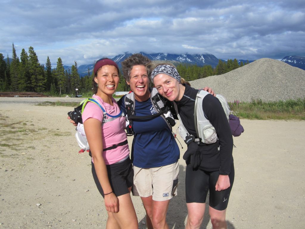
Here we are at the car greeted by our loyal support crew, Kari and Jack (I thought they were bears when I first saw them in the distance)  Success!  35.5 miles through the rain forest of Southeast Alaska and the alpine of British Columbia on the Chilkoot Trail.  Anyone for a beer?


Elevation Stats from my GPS Watch
The run starts near sea level in Dyea, Alaska.  The highest point (the U.S./Canadian border) was 3550 feet, so quite a climb in 16.5 miles (although Juneau Ridge trumps Chilkoot in elevation).  After the ridge, we dropped 1440 feet to a low point of 2110 feet at mile 26.2 around Lindemann City.  And, then we slogged uphill 815 feet over the last 8.5 miles or so.  
There you have it.  Join us next summer.  Cheers!

**Note:  I hiked the Chilkoot in July 2013 with my friend Sharon B.  It took us about an hour longer to fast hike it versus run the route and the pass was fogged in and icy.  

Sunday, July 1, 2012

Hiking the Backside of Douglas Island

After months of dreary, overcast skies and chilled rain, last Thursday the sun split the clouds and lit up the soggy rainforest for four perfect days. Juneauites emerged pale and squinting, and all 30,000+ denizens of this perpetually wet Alaska town went a little crazy. Everywhere people were fishing, hiking, strolling, running, biking or simply drying out (in the truest sense of the word).  It happened to be solstice as well, and finally the nights indeed seemed long and languid. So to celebrate my friend, Sharon Buis, and I decided to hike the perimeter of the the uninhabited side of Douglas Island. We both live on Douglas Island which is across the channel from Juneau. The "backside" of Douglas has no roads, no trails, and no people...except for us on this gorgeous Saturday in late June. We started in the morning at 5:15 a.m. from Sandy Beach just south of Douglas and across the channel from the cruise ship berths. At this early hour, the sun was already above Sheep mountain; something you only see around summer solstice.


The residents of Juneau are kinetic folk and many love to hike. But, I hadn't heard of anyone venturing around the backside of Douglas. I asked around and finally got in touch with a young guy who had hiked it with his buddy last summer. We spoke briefly on the phone and he told me it was "grueling". He said he started at 5:00 a.m. and finished at 10:00 p.m. He warned me that I'd be wet all day and should stay on the shore as much as possible despite all the rocks. He concluded by telling me he would never hike it again. Not exactly the endorsement I was hoping for...but it was a rare, hot and cloudless day in southeast Alaska, and Sharon and I were off.


The first few miles after Sandy Beach were trailed and pleasant as we hiked on the beach watching a cruise ship navigate its way into Gastineau Channel.  After about four miles of beach and Sitka Spruce, suddenly we stumbled upon several cabins nestled on lawns carved out of the forest. We heard music..."Uncle John's Band" from the Grateful Dead was wafting through the air (at 6:45 a.m.!), and a 60ish man with longish gray hair was strolling through the grass in cover-alls under a huge sign reading "Lucky Me". Sharon explained that someone had won the cabins in a poker game.
 

We turned around for one last glance towards Juneau before reaching the south end of the channel around mile 6. So far, we had crossed only two streams and traversed slippery rocks covered with sea grass. Totally tame.

We reached the southside of the island near low tide. We did this intentionally based on the advice of last year's hiker who had traversed in the opposite direction (Outer Point to Sandy Beach). He warned me of the rocky shore and steep walls particularly near the southside and he said he hadn't timed it with the tides and it was "brutal".  We wouldn't have timed it with the low tide either if we hadn't gotten his advice.
 

But, as we had planned, it was an hour before low tide as we approached the southern corner, and we simply strolled across the tidelands inland of Marmion Island.  We started seeing Bull Kelp in the water; something we don't find near my home on the north side of the island.


Soon the beach was again strewn with rocks and covered with barnacles and Blue Mussels. Then the rocks grew larger, and then again, even larger.  After about thirty minutes we were no longer hiking but climbing through several rocky outcroppings.  After an hour of balancing on jagged, igneous rock, I sort of wished I were back sprawled in the sun on the lawn at Lucky Me listening to the Grateful Dead and smoking...no, never mind.


I'll admit that the next several hours were my least favorite part of our hike.  We climbed our way around fifteen or so outcroppings covered with sharp-edged shells.  My knee started bleeding after I simply rested up against one of the mussel-laden walls. I hadn't anticipated climbing as much as we did and our options were dwindling as the tide came in.  The outcroppings separated the numerous tiny bays between Marmion Island and Point Hilda (a distance of approximately 11 miles).   


As the tide came in, we were unable to maneuver our way around a few of the rocky barriers between the bays and we scrambled up into the woods and followed animal trails.  By noon we could see Point Hilda 8 miles ahead with myriad, tiny, rocky bays tucked in between.


Around noon it hit me how far we had to hike and how long it would likely take us. Generally there was one waterfall per bay and if we couldn't easily cross through, we climbed up and around the falls through the woods.  I enjoyed hiking in the cool woods on the spongey, moist forest floor. Needless to say our feet were continuously wet despite the warm weather.


After a few more hours of patiently climbing over and around rocks or up into the woods as we did in the picture on the right, we were finally within a couple of miles of Point Hilda. 

Here the beach suddenly turned sandy.  It was incredible how sweet it was to stroll along the beach and simultaneously peer out at the water without risking a sprained ankle.  We learned later that the temperature reached 82 degrees.  That's a heat wave in Juneau given that the average temperature has been hovering around 49 degrees for most of May and June.  I took a deep breath and let the warmth sink in. Meandering down the sandy beach under the hot sun, but for the snow-capped peaks, I felt like I could have been on Kaui or on some other tropical island.


After hours of staring at grey rocks, I started to enjoy the afternoon and appreciate the unique beauty of southeast Alaska.  Both Sharon and I noticed that the southwest side of Douglas Island is drier, and luckily we encountered less under-brush (Devil's Club) in the woods.  There was also very little bear scat and most of the trails had only deer tracks.  We chatted about this as we walked in the sun, but there was one nagging thought at the back of my mind about a large outflow of water that I'd seen during a virtual fly-over on ShoreZone.  ShoreZone is NOAA's electronic mapping of Alaska's coast: http://mapping.fakr.noaa.gov/szflex/


And, yep, here it was: we came across the largest outflow about half a mile before Point Hilda. Did we feel like swimming?  It was around 4:20 p.m., and after traversing 20 miles over rocks, and knowing we had at least five hours of hiking left, we were loathe to waste more time schlepping back into the woods to find a shallower crossing point.

We forged through the stream.  The water was a bit chilly but not bad actually although Sharon's cell phone did get wet and die on us.  Have I mentioned that after 20+ crossings, our feet were wet all day?
 
We ate a quick dinner of sandwiches after we rounded Point Hilda and hiked to Inner Point where we passed kayakers setting up their tents in the early evening sun.  Then we headed to Middle Point where we forged a fast-flowing stream.  The rocks were back with a vengeance.  I've run my share of 50k routes but balancing with each step on slippery rock was a new exercise in concentration and forced slowness.  We didn't talk much at this stage and slowly moved ahead watching our every step.

Now we were getting tired and it was close to 9:00 p.m. and the rocks again were large and craggy.  Fortunately, we were treated to seven Humpbacks bubble-net feeding off the shore towards Colt Island and a busy Marmot land-side.  The noise from the whales' activity was tremendous and powerful, and momentarily I forgot my constant craving for Ibuprofen.


Listening to the sounds of the Humpback whales, we continued for several more miles balancing precariously on the rocks and, just after mile 28, we finally came to a beach I recognized and turned inward to a local trail.  We climbed up to the dirt path which felt wonderfully soft after miles of rock.  We hiked past several blazing camp fires, and twenty minutes later we were at Sharon's car at the end of the North Douglas highway.  According to my GPS we traveled exactly 30 miles from Sandy Beach to the end of the road on North Douglas.  It was 9:35 p.m., and we had started hiking at 5:15 a.m. Over 16 hours, including our multiple breaks...a long day! We clicked our beers together in a solstitial toast.  The next day I cycled another 14 miles to Sandy Beach from the end of the road to retrieve my car and complete the circle.  Would Sharon and I hike this route again?  No way.  Are we glad we hiked the backside of the island we inhabit?  You bet. 

Update April 2013: Today I kayaked around the island curious to see the mileage difference.  From the North Douglas boat ramp around the backside to Sandy Beach it was 30 miles (approximately 27 from the Outter Point - so 3 miles shorter than the hiking route).  The trip only took 9 hours.  It was a lot easier kayaking this route than hiking it!  I was treated to sea lions, seals, deer, about 1000 Scoters at Hilda Point (seriously...migrating south), loons and blow from Humpbacks.  There were only four fishing boats all day and the cruise ships haven't started, so no nasty wakes.  About two miles before Marmion Point, a float plane flew up behind me and over me, really low.  The pilot tipped his wings side to side to say hello!  Here are a couple of photos:


Friends Dea and Ben hiked the 30 miles around the backside last weekend (mid-April) and reported very few stream crossings unlike our June hike.  The snow is still high in mountains, so if you are crazy enough to venture around the island on foot, a sunny day in April may be the best time to do it.